How Accurate Are Phone GPS Systems?
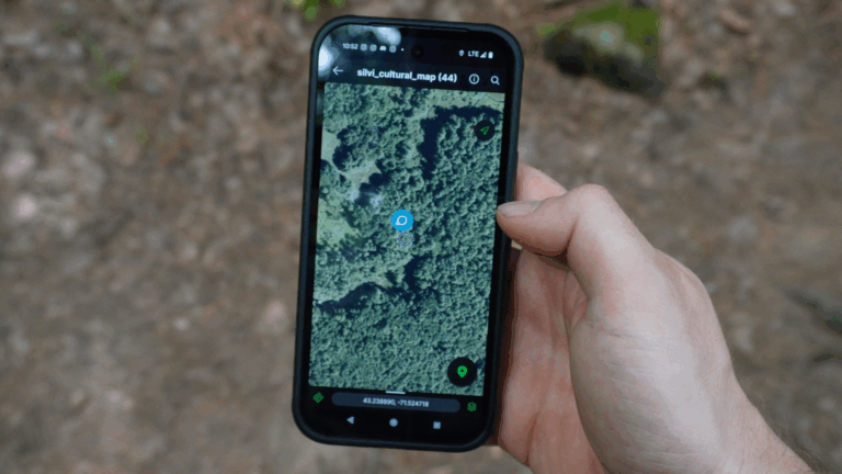
If you’ve ever wondered how accurate are phone GPS receivers, you’re not alone. Modern smartphones have become essential navigation tools for everything from daily commutes to outdoor adventures, and you can use them to leverage SilviCultural’s GeoTIFF export capabilities, but understanding their precision capabilities is crucial for knowing when you can rely on them.
Understanding Phone GPS Accuracy
Modern smartphones typically achieve GPS accuracy between 4.9 to 16 feet (1.5 to 5 meters) under optimal conditions. This level of precision is made possible by the integration of multiple technologies working together, including GPS, GLONASS, Galileo, and BeiDou satellite systems, along with assisted GPS (A-GPS) technology.
The accuracy of phone GPS has improved dramatically over the past decade. Today’s devices don’t rely solely on satellite signals—they combine data from cellular towers, Wi-Fi networks, and built-in sensors like accelerometers and gyroscopes to provide more reliable location information.
How Phone GPS Technology Works
Your smartphone’s GPS system works by receiving signals from multiple satellites orbiting Earth. By calculating the time it takes for signals to reach your device from at least four satellites, your phone can triangulate your position with impressive accuracy.
However, phone GPS systems go beyond basic satellite positioning. They use:
- Multi-GNSS support: Access to GPS (US), GLONASS (Russia), Galileo (EU), and BeiDou (China) satellite constellations
- A-GPS (Assisted GPS): Uses cellular network data to speed up satellite acquisition
- Wi-Fi positioning: Leverages known Wi-Fi network locations for additional accuracy
- Sensor fusion: Combines data from accelerometers, gyroscopes, and magnetometers to refine position
- Real-Time Kinematic (RTK): Some newer phones support RTK for centimeter-level accuracy in specific applications
Factors That Affect Phone GPS Accuracy
While phone GPS systems are remarkably accurate, several factors can impact their performance:
Environmental Conditions
Urban canyons created by tall buildings can cause signal reflection and multipath errors, reducing accuracy to 30-50 feet or more. Dense forests present similar challenges as tree canopy can block or weaken satellite signals.
Weather conditions generally have minimal impact on GPS accuracy, though heavy cloud cover or severe storms can slightly degrade signal quality.
Device Quality and Age
Newer smartphones equipped with modern chipsets and multiple antenna systems typically outperform older devices. Premium flagship phones often include better GPS hardware than budget models, though the difference is narrowing.
Satellite Visibility
Your phone needs a clear view of the sky to receive signals from multiple satellites. The more satellites your device can connect to, the better your accuracy. Indoors or in covered areas, accuracy can drop significantly or GPS may not work at all.
A-GPS and Data Connection
When your phone has an active data connection, A-GPS significantly improves both the speed and accuracy of position fixes. Without cellular or Wi-Fi data, your phone can still use GPS, but it may take longer to establish a fix and be slightly less accurate.
Real-World Phone GPS Performance
In practical testing scenarios, phone GPS accuracy typically falls into these ranges:
- Open sky conditions: 3-5 meters (10-16 feet)
- Suburban areas: 5-10 meters (16-33 feet)
- Urban environments: 10-30 meters (33-100 feet)
- Under tree cover: 10-50 meters (33-164 feet)
- Indoors: Often unreliable or unavailable
These measurements represent horizontal accuracy. Vertical accuracy (elevation) is typically 2-3 times less accurate than horizontal positioning.
Comparing Phone GPS to Dedicated Devices
When considering how accurate are phone GPS systems compared to dedicated receivers, the answer might surprise you. Modern smartphones perform comparably to consumer-grade GPS devices like Garmin handheld units in most situations.
Both phone GPS and consumer GPS devices:
- Use the same satellite constellations
- Achieve similar accuracy ranges (3-10 meters in good conditions)
- Face the same environmental limitations
- Provide adequate precision for recreational navigation
Dedicated GPS receivers may have advantages in battery life, ruggedness, and reliability in extreme conditions, but their core positioning accuracy is very similar to smartphones
Professional Applications: Forestry Fieldwork
For forestry professionals and natural resource managers, understanding the limitations and capabilities of phone GPS is essential. The good news is that phone GPS accuracy is entirely suitable for most forestry fieldwork applications.
Tasks that work well with phone GPS include:
- Plot location and relocation: Returning to established sampling points
- Trail mapping and layout: Recording paths and access routes
- General resource mapping: Documenting tree locations, water features, or wildlife observations
- Boundary approximation: Getting general property line references (not legal boundaries)
- Field navigation: Moving between work sites safely and efficiently
With accuracy typically between 3-10 meters under forest canopy, phone GPS provides sufficient precision for these operational needs. The accuracy is comparable to consumer models of GPS devices like Garmin handheld units, making smartphones a cost-effective and convenient tool for field professionals.
When Phone GPS Isn’t Accurate Enough
However, it’s important to recognize when phone GPS accuracy falls short. Survey-grade work requires significantly higher precision than phone GPS can deliver. Applications that demand greater accuracy include:
- Land surveying: Requires centimeter-level accuracy
- Legal boundary establishment: Needs professional survey equipment
- Construction layout: Demands precise positioning
- Precision agriculture: Often requires RTK or differential GPS
- Scientific research: May need sub-meter accuracy
For these applications, professional-grade GPS/GNSS receivers costing thousands of dollars are necessary. These systems can achieve accuracy from centimeter to sub-centimeter levels through techniques like Real-Time Kinematic (RTK) positioning and post-processing.
Maximizing Your Phone GPS Accuracy
To get the best possible accuracy from your phone GPS:
- Keep your device updated: Software updates often include GPS performance improvements
- Enable high-accuracy mode: Use settings that allow GPS, Wi-Fi, and cellular positioning
- Calibrate your compass: Regularly calibrate your phone’s magnetometer
- Allow location services: Ensure apps have proper permissions
- Wait for a good fix: Give your phone 30-60 seconds to acquire multiple satellites before moving
- Use external GPS apps: Some third-party apps provide better satellite information and accuracy readings
The Bottom Line
So, how accurate are phone GPS systems? Under typical conditions, modern smartphones provide accuracy between 5-15 feet, which is remarkably precise for a device that fits in your pocket. This level of accuracy is comparable to consumer-grade GPS devices from manufacturers like Garmin, making phone GPS perfectly suitable for recreational navigation, fitness tracking, and professional fieldwork applications like forestry work.
While phone GPS can’t match the centimeter-level precision of survey-grade equipment, it has become an incredibly reliable tool for the vast majority of location-based needs. For forestry professionals conducting plot work, timber cruising, or general resource mapping, phone GPS accuracy is more than adequate and offers the added benefits of portability, affordability, and integration with other digital tools.
The key is understanding the limitations: use phone GPS confidently for operational fieldwork, but recognize when professional survey equipment is required for legal or engineering-precision applications. With this knowledge, you can leverage your smartphone’s GPS capabilities effectively in the field while knowing when to call in the professionals for survey-grade work.