What Are Forest Stands? A Complete Guide to Forest Stand Identification and Management
If you own woodland property or are interested in forest management, you’ve likely encountered the term “forest stand.” But what are forest stands, exactly, and why do they matter for effective woodland stewardship? Whether you’re managing ten acres or ten thousand, understanding forest stands is essential for maximizing the ecological and economic value of your property.
In this comprehensive guide, we’ll explore everything you need to know about forest stands— from their basic definition to their critical role in sustainable forest management. We’ll also show you how modern technology, like that available to you on SilviCultural is revolutionizing stand identification, making professional-grade forest assessment accessible to landowners of all sizes.
What Are Forest Stands? The Basic Definition
A forest stand is a contiguous group of trees that share sufficiently uniform characteristics in species composition, age, size, structure, and condition to be distinguished from adjacent forest areas and managed as a single unit. Think of forest stands as the fundamental building blocks of forest management—distinct patches within a larger forest landscape that can be identified, mapped, and treated according to their unique attributes.
Forest stands are defined by several key characteristics:
Species Composition: The mix of tree species present in the area. A stand might be pure (dominated by a single species like loblolly pine) or mixed (containing multiple species like oak, hickory, and maple).
Age Class: The approximate age range of the dominant trees. Stands are often classified as even-aged (trees within 10-20 years of each other) or uneven-aged (trees spanning multiple age classes).
Size and Structure: The diameter and height of trees, canopy layers present, and overall stand density. These factors determine what foresters call “stand structure.”
Site Quality: The productive capacity of the land, influenced by soil type, slope, aspect, and moisture availability.
Condition: The health and vigor of the trees, including the presence of disease, insect damage, or other stress factors.
The boundaries between forest stands aren’t always sharp lines—they can be gradual transitions. However, recognizable differences in these characteristics allow forest managers to delineate distinct stands that respond differently to management interventions.

Why Are Forest Stands Necessary for Woodland Management?
Forest stands aren’t just an academic concept—they’re a practical necessity for effective forest management. Here’s why breaking your forest into distinct stands is essential:
Tailored Management Prescriptions
Trees with similar characteristics have similar biological needs and respond predictably to management treatments. A 40-year-old loblolly pine plantation ready for first commercial thinning requires completely different management than an 80-year-old mixed hardwood stand ready for regeneration harvest. By identifying distinct stands, you can develop specific prescriptions for each area rather than applying a one-size-fits-all approach that inevitably leaves value on the table.
Economic Optimization
Forest stands allow you to time harvests strategically for maximum financial return. Some stands might contain merchantable timber ready for harvest, while adjacent stands need several more years of growth. Stand-level planning helps you schedule operations efficiently, minimize logging costs, and capture timber at peak value. Without stand delineation, you might harvest immature trees prematurely or miss the optimal harvest window for mature timber.
Sustainable Resource Management
Managing forests at the stand level enables sustainable forestry practices. You can track growth rates, monitor regeneration success, and ensure that harvest levels don’t exceed sustainable limits. This approach allows you to maintain continuous forest cover while still generating income, creating what foresters call “sustained yield management.”
Wildlife Habitat Enhancement
Different wildlife species require different habitat types. White-tailed deer thrive in young, dense regeneration stands with abundant browse. Wild turkeys need mature hardwood stands with mast-producing trees. By managing distinct stands with different characteristics, you create habitat diversity across your property, supporting a wider range of wildlife species.
Regulatory Compliance and Certification
Many forestry best management practices (BMPs) and certification programs like the Sustainable Forestry Initiative (SFI) or Forest Stewardship Council (FSC) require stand-level planning and documentation. Clearly defined stands make it easier to demonstrate sustainable management practices and maintain certification status.
How Forest Stands Aid in Forest Management: Practical Applications
Understanding what forest stands are is one thing—seeing how they function in real-world forest management is another. Let’s explore the practical applications of stand-based management.
Forest Inventory and Assessment
Forest stands provide the organizational framework for timber cruising and inventory. Rather than attempting to inventory an entire property as a single unit, foresters sample representative plots within each stand and extrapolate results across the stand area. This approach provides accurate volume estimates while minimizing time and cost. Stand-level data allows you to track growth over time, calculate allowable cut, and make informed decisions about harvest timing.
Silvicultural Planning
Silviculture—the art and science of controlling forest establishment, composition, and growth—operates primarily at the stand level. Each stand requires its own silvicultural prescription based on landowner objectives and current stand conditions. A young, overstocked pine stand might need pre-commercial thinning to concentrate growth on the best trees. A mature hardwood stand might benefit from single-tree selection to maintain uneven-aged structure. Stand delineation allows you to match silvicultural treatments to stand conditions, achieving your management goals efficiently.
Harvest Planning and Logistics
Logging operations are planned and executed at the stand level. Distinct stands allow you to design efficient skid trails, plan landing locations, and estimate operational costs. You can schedule harvests based on stand readiness, market conditions, and cash flow needs. Stand mapping also facilitates communication with logging contractors, ensuring everyone understands exactly which trees should be cut and which areas should be protected.
Regeneration and Reforestation
After harvest, regeneration strategies vary by stand. Some stands regenerate naturally from existing seed sources, while others require planting. Stand-level planning helps you choose appropriate regeneration methods, select suitable species for site conditions, and monitor establishment success. You can track which stands need regeneration attention and schedule planting or release treatments accordingly.
Risk Management and Adaptive Management
Forest stands allow you to diversify risk across your property. By maintaining stands of different ages, species, and structures, you reduce vulnerability to catastrophic losses from insects, disease, fire, or storms. If one stand is damaged, your other stands continue to provide value. Stand-level monitoring also enables adaptive management—you can evaluate treatment outcomes in individual stands and adjust your approach as needed.
Record Keeping and Documentation
Comprehensive forest management requires detailed records. Stand-based record keeping allows you to document what treatments were applied where and when, track costs and revenues, and monitor long-term trends. This information is invaluable for tax purposes, estate planning, and ensuring management continuity if ownership changes.
Traditional Methods of Forest Stand Identification
Historically, identifying forest stands required extensive fieldwork. Foresters would walk property boundaries, noting changes in species composition, tree size, density, and other characteristics. They’d mark stand boundaries with flagging tape, create hand-drawn maps, and conduct detailed timber cruises within each stand. This process was time-consuming, expensive, and required significant expertise.
Aerial photography improved stand identification by providing a bird’s-eye view of the forest canopy. However, standard color photography has limitations—similar-looking canopies might contain very different tree species, ages, or conditions that aren’t visible in conventional images. Ground truthing remained essential, requiring multiple site visits to verify what aerial photos suggested.
For small woodland owners, the cost and complexity of traditional stand delineation often meant managing without detailed stand maps or relying on outdated information. Many landowners made management decisions based on general impressions rather than precise stand-level data, potentially missing opportunities or making suboptimal choices.
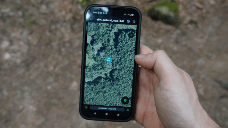
How SilviCultural Revolutionizes Forest Stand Identification
Modern technology is transforming how forest stands are identified and mapped. SilviCultural’s forestry mapping software leverages advanced remote sensing tools that were once available only to large industrial forestry operations, making professional-grade forest assessment accessible and affordable for landowners of all sizes.
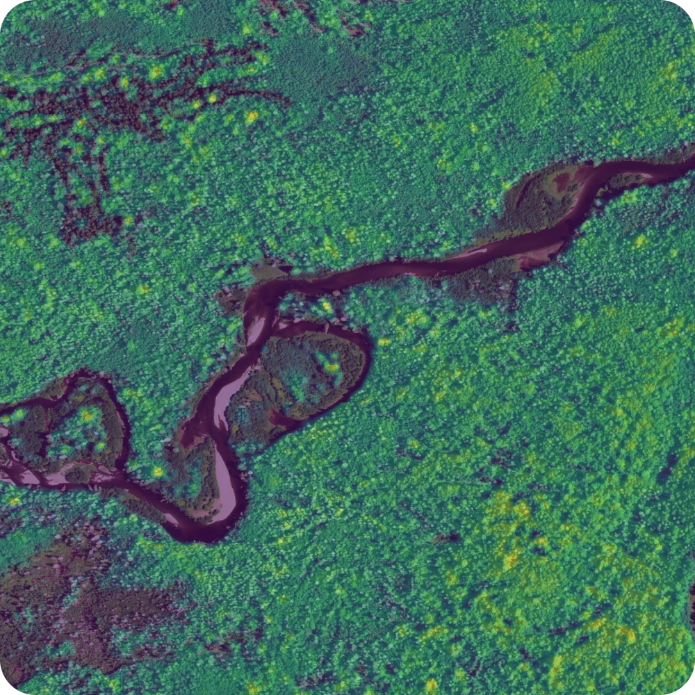
Color Infrared (CIR) Imagery for Stand Delineation
One of SilviCultural’s most powerful features for identifying forest stands is Color Infrared (CIR) imagery. Unlike standard aerial photography, CIR captures wavelengths of light invisible to the human eye—specifically, how vegetation reflects near-infrared energy.
Here’s why CIR imagery is a game-changer for stand identification:
Species Differentiation: Different tree species reflect infrared light in characteristic ways based on their leaf structure and chemistry. Hardwoods and conifers show distinct signatures. Even within hardwoods, oaks often appear different from maples or hickories. This allows you to identify species composition patterns that define stand boundaries—patterns that might be invisible in standard color photos.
Health and Vigor Assessment: Healthy, actively photosynthesizing vegetation appears bright red in CIR imagery, while stressed or declining trees show up darker. This helps you identify stand boundaries based on tree condition and vigor, spotting potential problem areas that need attention.
Age Class Visualization: Younger, faster-growing trees often show brighter infrared reflectance than older, slower-growing trees. This helps distinguish between age classes, making it easier to delineate even-aged stands or identify age-class boundaries within complex stands.
Canopy Density Patterns: CIR imagery clearly shows variations in canopy closure and density. You can easily spot openings, gaps, and areas of regeneration versus fully stocked mature stands—critical information for stand delineation and management planning.
With SilviCultural’s CIR imagery, what appears as uniform green forest to the naked eye becomes a detailed map of distinct vegetation patterns. Stand boundaries that would take days to identify on the ground become apparent in minutes of screen time, dramatically reducing the time and cost of forest assessment.

LiDAR Canopy Height Data for Structural Analysis
While CIR imagery reveals species and health patterns, LiDAR (Light Detection and Ranging) adds the crucial third dimension: forest structure. SilviCultural’s LiDAR canopy height data provides unprecedented detail about the vertical structure of your forest, essential information for identifying stands based on timber size and developmental stage.
LiDAR works by sending laser pulses from aircraft and measuring how long they take to return after bouncing off the forest canopy and ground. This creates incredibly detailed elevation models showing the exact height of vegetation across your property.
For forest stand identification, LiDAR offers multiple advantages:
Precise Height Mapping: See exactly how tall trees are in every part of your forest. Areas with 70-foot trees are clearly distinct from areas with 40-foot trees, helping you delineate stands based on timber size class—a critical factor in determining stand maturity and management options.
Structural Class Identification: LiDAR reveals whether you’re looking at mature sawtimber, pole-sized timber, or young regeneration. This allows you to identify stand boundaries based on developmental stage, ensuring each stand is managed according to its current structural characteristics.
Volume Estimation: Tree height is a key variable in timber volume calculations. LiDAR-derived height data allows you to estimate standing timber volume at the stand level without extensive ground measurements, helping you identify which stands contain the most valuable timber.
Topographic Context: LiDAR simultaneously captures ground elevation, showing you how topography relates to stand boundaries. You might discover that stand boundaries follow ridgelines, drainages, or slope changes—information that influences both stand delineation and management feasibility. This is available as the slope and hillshade model in your data layers.
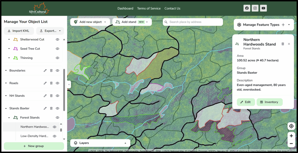
Integrated Analysis with SilviCultural
The real power of SilviCultural comes from integrating CIR imagery and LiDAR data into a comprehensive forest assessment platform. By overlaying these data layers, you can:
- Identify stands based on multiple criteria simultaneously (species, health, age, size, structure)
- Generate preliminary stand maps quickly, then refine boundaries based on your field knowledge
- Share maps with consulting foresters or logging contractors and lessees.
- Make data-driven management decisions with confidence
SilviCultural transforms forest stand identification from a time-intensive field exercise into an efficient desktop analysis, followed by targeted field verification. Instead of walking every acre flagging boundaries, you can focus ground time on confirming key boundaries and collecting detailed data within stands you’ve already identified remotely.
Getting Started with Forest Stand Management
Understanding what forest stands are and why they matter is just the beginning. Here are practical steps to start implementing stand-based management on your property:
- Create a Base Map: Use SilviCultural’s CIR and LiDAR layers to identify obvious stand boundaries based on species, height, and health patterns.
- Field Verify Boundaries: Walk your property with your preliminary stand map, confirming boundaries and noting any adjustments needed based on ground conditions.
- Develop Stand Descriptions: For each stand, document key characteristics: dominant species, age class, average diameter and height, stocking level, and overall health.
- Set Stand-Level Objectives: Determine what you want each stand to provide—timber revenue, wildlife habitat, aesthetics, recreation, or some combination.
- Create Management Prescriptions: With help from a consulting forester if needed, develop specific management recommendations for each stand based on current conditions and your objectives.
- Implement and Monitor: Execute treatments according to your plan, then monitor stand responses and adjust as needed.
Conclusion: The Future of Forest Stand Management
Forest stands are the fundamental units of effective woodland management, allowing landowners to tailor treatments to specific site conditions and achieve diverse objectives across their property. Understanding what forest stands are and how to identify them is essential for anyone serious about forest stewardship.
Modern technology platforms like SilviCultural are democratizing access to the tools professional foresters have used for decades. By combining CIR imagery’s species and health detection capabilities with LiDAR’s structural analysis, landowners can now identify forest stands with unprecedented speed and accuracy. This technology doesn’t replace field knowledge and professional forestry expertise—it enhances them, allowing you to make smarter decisions and manage your woodland more effectively.
Whether you’re planning your first timber harvest, working to improve wildlife habitat, or simply trying to understand what you own, starting with a solid understanding of your forest stands is the foundation of success. The question isn’t whether you can afford to invest in stand-level mapping and planning—it’s whether you can afford not to.
Ready to see your forest’s distinct stands and unlock its full potential? Discover how SilviCultural’s advanced imagery and data layers can transform your forest management approach today.